Special Report Demand for Ports to 2050: Climate Policy, Growing Trade and the Impact…
페이지 정보
작성자 최고관리자 댓글 0건 조회 2,089회 작성일 21-01-14 15:29본문
1. Introduction
Since the 1980s, port areas have significantly developed due to increasing seaborne trade, growth in the use of containers, as well as improving standards of operation and management. This has been driven largely by global economic integration, trade liberalization under the World Trade Organization and the opening of China's economy as around 80% of trade is carried by sea(OECD/ITF, 2017; UNCTAD, 2017). Future trade projections are mainly based on population and economic activit (e.g. Fontagné et al., 2017; Keck et al., 2018). Recent trade scenarios suggest that global freight demand could increase between three‐ and seven‐fold by 2050(e.g. IMO, 2015), while OECD/ITF(2017) suggest a 73% global increase in the number of containers moved to at least 2.2 billion per year over the same period. It has been estimated that port capacity will not be adequate to meet demand as early as 2030(e.g. OECD, 2012); increases in capacity and infrastructure are already inevitable to ensure efficient movement of goods(e.g. ADB, 2010a; OECD, 2011; OECD/ITF, 2016).
Climate‐related extremes and trends have important implications for ports in terms of their functionality, navigable water, and shelter from wind and waves. The physical and economic consequences of extreme events such as Hurricanes Sandy and Katrina are well known(e.g. Grenzeback & Liukman, 2008; Hallegatte, 2015; Kunz et al., 2013; Smythe, 2013). More specifically, port closure and recovery duration and costs can be significant (PANYNJ, 2019; Verschuur et al., 2020)–many countries close ports prior to predicted extreme events as, in addition to wind, floods due to storm surge can cause major damage(e.g. Mori et al., 2019; Wadey et al., 2015; Wakeman & Miller, 2013). While such major events are expected to increase in intensity if not frequency over this century as a consequence of climate change and sea‐level rise(e.g. McLeod et al., 2018), ports are commonly designed to maintain functionality in relation to extreme water levels of known probability(e.g. 1 in 100 years). As relative sea level rises, a consequence of land subsidence/uplift and climate‐induced sea‐level change linked to future greenhouse gas emissions(Nicholls et al., 2014), the likelihood of such events increases substantially(e.g. Feng et al., 2018; Oppenheimer et al., 2019; Tebaldi et al., 2012).
Looking to the future, ports will therefore need to adapt to the consequences of sea‐level rise, while also responding to changes in seaborne trade. Climate policy, by influencing global temperature rise, will have an impact on both these factors. Most previous analysis of ports under climate change focus on risk assessment and adapting existing ports to sea‐level rise(e.g. Asariotis et al., 2018; Becker et al., 2016; Dronkers et al., 1990; Ng et al., 2018) with a focus on upgrading existing port infrastructure to compensate for this effect and maintain functioning capacity. The impact of climate‐influenced changes in seaborne trade and, consequently, port capacity is less well explored. As adapting existing infrastructure and planning and construction of new ports is time‐consuming and will require significant capital investment(e.g. recent major expansion of existing and construction of new port areas in the growing economies of China, India and Africa, see ADB, 2010b; Kavas, 2015), exploring the potential impact of climate policy is beneficial over both the short and long‐term(OECD/ITF, 2016).
To examine the future of ports including the effect of climate change policy, this paper analyses consistent trade and sea‐level scenarios to 2050 to explore the required port area, including requirement for new port area, and the adaptation needs for existing ports. As global climate policy to regulate greenhouse gas emissions is increasingly likely to influence how the demand for maritime transport evolves(Walsh et al., 2019), the trade and climate scenarios consider the effects of low and high levels of global CO2 mitigation. Hence, this analysis provides a more comprehensive perspective on these changes and associated costs than previous assessments.
2. Approach
Ports are strategic and valuable areas which will need to be sustained and probably expanded to support global economic health. For future planning it is useful to explore how the demand for port infrastructure may change. In this analysis the current and future area and costs for ports based in the handling of sea‐borne freight at national and regional levels under future climate‐orientated scenarios is estimated. It is based on the following assumptions: (i) if trade expands, additional port areas will be required, (ii) future climate policy (or not) will influence the mix and quantity of commodities traded(e.g. Burke et al., 2015), (iii) there is a direct relationship between the type of cargo, volume of goods and handling technique(e.g. Merk & Dang, 2012; Walsh et al., 2017), and (iv) relative sea‐level rise can be offset by raising port areas(e.g. Dronkers et al., 1990; Esteban et al., 2019). To maintain their viability and functionality, ports will therefore need to undertake adaptation measures to existing areas and expand where necessary. While the methodology contains appropriate simplifications and assumptions, it provides indicative estimates of potential future challenges and the need for appropriate strategic planning. The assessment of future port area depends on robust estimates of port throughput of both wet and dry bulk materials and containers which are provided by climate‐policy driven trade scenarios and adaptation implications of associated Intergovernmental Panel on Climate Change(IPCC) emissions scenarios. The methodology considers the provision of port area and associated costs only; the upgrade or provision of protective breakwaters and other related hard infrastructure is not included. Hence, the costs must be considered minimum estimates.
(1) Methodology
At the regional and national levels addressed here, current and potential port area for each country with maritime ports are calculated using an improved methodology based on that by Delft Hydraulics which was used in the first estimate of the global costs of protecting against sea‐level rise(Dronkers et al., 1990). The original method used annual trade(reported tonnage, including containers) to estimate the required port area in 1990 based on the analysis of the relationship between cargo and area in selected ports. A uniform 1‐m relative sea‐level rise was then assumed in order to calculate adaptation costs.
Sea‐borne trade is mainly carried by three ship types; (i) 'wet' bulk trade such as oil and petroleum products, (iii) 'dry' bulk trade such as iron ore, coal, grain, feed and fertilizers, and (iii) containerized trade which can range from food products to electronic goods. Each type requires different port‐based facilities, storage and handling methods, and consequently have different space demands. Dronkers et al. (1990) recognized this but were unable to differentiate between types due to lack of data. The methodology used here differs from Dronkers et al. (1990) by differentiating between goods carried by (i) bulk carriers and (ii) containers. The method for bulk trade follows Dronkers et al. (1990), while the area required for containers uses up‐to‐date design criteria, including variances between import and export, for handling and storage (Thoresen, 2014).
The methodology also incorporates change over time, as represented by change in area and maintaining land‐water levels for port functionality. For coastal ports, the latter is influenced by relative sea‐level change which is increasingly considered in port planning and design(e.g. HR Wallingford, 2014; Moffatt and Nichol, 2016; PANYNJ Engineering Department, 2015). The use of spatially variable values of relative sea‐level rise are a further improvement on Dronkers et al.(1990). The resulting methodological approach adopted is summarized in Figure 1.
These extensions to the methodology allow the estimation of (i) the port area required to handle both tonnage and containers for a given amount of trade for baseline(2010) and future conditions(to 2050) and, in response to relative sea‐level change over the same period, (ii) the adaptation costs for baseline areas to maintain relative land‐water working levels, and (iii) construction costs of any new port areas required.
(2) Trade Scenarios
The trade data used is globally consistent, linking different emissions scenarios to goods and commodities and subsequently to ship type. Four contrasting scenarios of international maritime transport demand to 2050, consistent with high and low levels of global CO2 mitigation and associated climate impacts(see Walsh et al., 2019 for full details), are considered(see Figure 2).
Two scenarios are characterized by a low global temperature increase of 2°C by 2100 and low material intensity (named Green Road(GR) and Middle Road 2C(MR2C)). These lead to a lower increase in trade, but a high growth in demand and movement of bioenergy commodities. The resulting trade growth is lower than those in many existing trade scenarios and forecasts. In contrast, scenarios High Road(HR) and Middle Road 4C(MR4C) assume limited greenhouse gas mitigation and higher global temperature increase of 4°C by 2100, projecting higher trade growth and continued growth in expanding markets. This leads to a quadrupling of trade across all commodities under the HR scenario. The MR4C scenario shows a slightly lower increase in trade related to the socio‐economic assumptions in the MR scenarios. Across the scenarios, trade is therefore projected to increase between two and four times by 2050 compared to 2010.
Each scenario provides a decadal(2010–2050) matrix of goods quantities transported by sea(as containerized, dry or wet bulk commodities) between 16 regions of the world, which are further divided into national quantities of imports and exports(SCC Consortium, 2020). As the scenarios consider international goods flows only, port space required for the movement of tonnage and containers within national boundaries is not included in the port area calculations. Trans‐shipment traffic is included within the import and export values and counted as two events at the port(once to load and once to off‐load). For land‐locked countries, assigned trade is assumed to pass through a neighboring coastal country and forms part of that countries' required port area.
(3) Port Area Estimates
Separate port area calculations are carried out for bulk trade and containers. Area estimates include quays, storage areas, roads and general areas including trans‐shipment. For containers space differences associated with handling method(Thoresen, 2014) are also considered.
① Wet and Dry Bulk Traffic(Tonnage)
A representative value of 3×10⁶ tonnes/yr/km2 is used to calculate the port area required to handle bulk cargo based on the analysis of 27 globally distributed ports(see Figure 3 and Dronkers et al., 1990). This representative value is maintained in the revised methodology for both wet and dry bulk due to the lack of more recent globally‐applicable information which enables distinction in space requirements for the two types. Therefore, following Dronkers et al.(1990), a multiplier of 0.23 is applied to tonnage projections to account for any variation in the handling areas between wet and dry bulk. Import and export tonnage are assumed to require the same amount of space.
② Containers
Equation 1 from the 'Port Designers Handbook'(Thoresen, 2014) is used to determine port area for containers. This includes the stacking area, internal road system and handling area required. The calculation is based on an annual forecast of container numbers with separation between imports and exports:
where
AT = total port area needed
ATEU = area required per container, dependent on handling system.
CTEU = container movement/year.
H = ratio of average stacking height to maximum stacking height for containers (0.5–0.8)
D = dwell time or the average number of days the container stays in the stacking area (an average of 7 days for import containers and 5 days for export containers).
L = layout factor due to the shape of the storage area (0.7–1).
Bf = buffer storage factor in front of the storage area (0.05–0.1).
N = primary yard (stacking) area compared to total yard factor (0.6–0.75)
S = segregation factor due to different container destination, maintenance etc. (0.8–1).
For the purposes of this study a number of assumptions are made; (i) import and export containers are treated as being exclusive in terms of area required and (ii) the handling method can be applied at country level(see Section ③).
③ Handling Efficiency
The management of bulk tonnage is assumed to maintain its efficiency over time and be globally consistent. For containers, an initial area per container(ATEU) at country level is set using World Bank income categories(World Bank, 2016). High Income countries are assumed to have the most efficient ports(6 m2 per container) and Low Income countries the least efficient(36m2 per container)(Table 1). This may not reflect reality as port ownership and investment vary both within and between countries, but provides a basis from which the effect of efficiency on the future port areas can be explored. The storage area (L) is assumed to be rectangular with a factor of 1 and other factors are set at the higher value.
(4) Sea‐Level Rise Projections
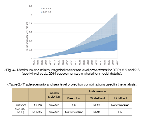
To link with the climate futures within the trade scenarios, two Representative Concentration Pathways(RCPs) 8.5 and 2.6, are considered. RCPs are greenhouse gas concentration trajectories recommended by the IPCC; RCP8.5 is characterized by increasing greenhouse gas emissions over time to 2100 and RCP2.6 shows a peak in greenhouse gas emissions mid‐century followed by a decline to very low emissions. The corresponding temperature rise by 2100 is estimated to be 1 to 2°C for RCP2.6 and 3.5 to 5.5°C for RCP8.5, relative to pre‐industrial values(IPCC, 2013), comparable to the trade scenario assumptions of 2 and 4°C. As there are uncertainties within sea‐level projections(e.g. Oppenheimer et al., 2019; WCRP Global Sea Level Budget Group, 2018), maximum and minimum sea‐level values for each RCP are projected. Due to the long time lag in the ocean response to the temperature change related to the greenhouse gas concentrations, both projections show an increase in mean sea‐level change over this century and, together, represent the potential range in sea‐level projections(see Figure 4).
To obtain relative sea‐level values at country level, the DIVA database(Hinkel et al., 2014; Vafeidis et al., 2008) is used. This combines glacial isostatic adjustment and a simple treatment of delta subsidence with the patterned mean sea levels associated with the two RCP trajectories to generate characteristic, spatially variable, relative sea‐level change. Human‐induced subsidence, such as that found in many Asian cities, is not considered. The sea‐level rise projections are combined with the trade scenarios as shown in Table 2.
(5) Cost Estimates for Adaptation and New Port Construction
Costs are assessed as a 'one‐off' investment incurred in the base year and are therefore not subject to discount rates or inflation. As costs are based on Dutch sources, the relative country cost factors from the original report (Dronkers et al., 1990) are retained; this factor recognizes the relative differences considering the presence of a 'wet' civil construction industry, land acquisition cost, availability of human and material resources and the local market situation.
For adaptation to relative sea‐level rise, costs are based on the assumption that port areas should maintain their existing level relative to mean sea level to preserve risk levels for inundation. It is assumed that all port areas are flat and raising with relative sea‐level rise will suffice. It does not consider other port facilities that might need adaptation, including harbor breakwaters and defenses. For the elevation of port areas, the unit cost reported in Dronkers et al.(1990) was inflated to 2010 prices using the U.S. Retail Price Inflation (Annual Average) to give 25.5 million USD/km2/m. Only port areas existing in 2010 are assumed to require this adaptation.
Additional port area demand is represented by the difference between the projected and base year areas(see Figure 1). For the costing of these areas, it is assumed that any new area will be an extension of an existing port and therefore will only require partial land reclamation(see Figure 5). A representative berth depth was taken from national maximum as reported in the World Port Index (WPI, 2015) under the assumption that ports will continue to accommodate the largest ship currently serviced. The costs for new port construction were based on those reported for the Maasvlakte2 development in Rotterdam which include land reclamation and construction of infrastructure. The unit cost, including inflation to 2010, was calculated to be just over 11.6 million USD/km2/m.
(6) Comparison With Other Data Sources
The results presented here are difficult to validate as national and global data on actual port size is not readily available. The 2010 baseline global port area estimated by the updated method is less than the area estimated in Dronkers et al.(1990), 1,364km2 in contrast to 1,693km2, despite significant increases in global trade between 1990 and 2010(see Figure 1.1 in UNCTAD, 2018). Some of this reduction reflects separation of tonnage and containers as container handling generally requires less space than bulk cargo. Additionally, the results of this analysis are based on the globally consistent throughput of international goods and commodities rather than reported tonnage which is often a combination of multiple sources and dates(e.g. UNCTAD, 2018) and are recognized to include national coastal shipping(Dronkers et al., 1990).
Table 3 indicates that results are conservative when compared to land use analysis for Australia(ABARES, 2011) and the European Union(Corine data(Copernicus, 2012)) at national level, although digital identification of boundaries between port areas required for goods and other urban or industrial areas are recognized as problematic(e.g. EEA, 1995). Other national differences with Dronkers et al.(1990), notably China and Japan, can be related to post 1990 changes in economies and maritime trade patterns, although Table 3 also shows similar variation with more contemporary reported throughput.
Comparison of estimated areas for containers with other data sources(Table 4) show more consistency, although there are still notable variations. The major economies of China, Japan and the United States again show the largest differences.
3. Future Port Area and Costs
(1) Global Port Area and Costs
All of the scenarios show an increase in port area by 2050 when compared to the baseline year of 2010. MR2C shows the lowest increase but still, along with GR, effectively requires a doubling of port area. HR, the highest increase, requires a four‐fold increase in area reflecting the increased material intensity of this scenario(Table 5). MR4C has a substantially lower port area than HR, although the global temperature projections are the same. This reflects that while MR4C exhibits strong growth rates in world trade, these do not appear until post 2030 when its trajectory deviates from the other Middle Road scenario (MR2C).
The movement of bulk commodities remains the dominant type of maritime trade, representing between 72 and 81% of total maritime freight globally. Changes in the energy sector are an important variant between the scenarios as energy commodities make up about 40% of sea‐borne trade(UNCTAD, 2016). Compared to the HR scenario in which there is continued consumption of fossil fuels, the MR2C scenario has a reduced demand for the transport of both wet and dry bulk energy commodities such as coal and oil due to the large growth in nuclear and more localized power generation and electrification of transport in this scenario. Under the GR scenario, the dry bulk percentage remains high as the scenario focusses on bioenergy sources and movement of biomass such as wood and cork. Both mitigated climate scenarios also anticipate a decline in coal trade to near zero. The percentage of area required by wet bulk remains fairly constant as, although the causes may differ, all the scenarios project continued movement of refined oil products and increasing trade in liquid natural gas(LNG) as an energy source. For the handling of containers, the more sustainable GR scenario shows the lowest area demand for this ship type in 2050(633km2) while the globalized high material intensity of the HR scenario results in a port area of 1,055km2. However, as a percentage of total area, containers remain fairly consistent.
Total costs are substantially higher under the HR scenario. The vast majority is associated with the need to construct new port areas to handle projected increases in global maritime trade. HR has significantly higher port area and therefore higher costs than the other three scenarios, and at 750 billion USD is almost than double the cost of MR4C, the other unmitigated climate future. The adaptation of baseline port areas to relative sea‐level rise are not strikingly different under the unmitigated(HR and MR4C) and mitigated(MR2C and GR) climate futures, reflecting that sea‐level rise in 2050 is similar under both RCPs(Figure 4). Being under 20 billion USD globally, costs for adaptation represents less than 6% of the cost for construction of new port areas under all scenarios in 2050. However, by 2100, there are significant differences between the mitigated and unmitigated futures even assuming no further increase in required port area; adaptation costs increase by 250% for the HR and MR4C scenarios compared to 50% under the MR2C and GR scenarios(Table 5). However, globally, total adaptation costs still only represent a small percentage of global GDP so can be seen as affordable.
(2) Spatial Variation
The distribution of the growth in port area, and therefore total costs, varies regionally and by scenario. The High Road scenario sees significant increases across regions while, comparatively, the Green Road scenario has a lesser impact although individual countries such as Nigeria will still need to almost double their capacity. For individual countries, the actual area increase can appear relatively small, for example Guyana's maximum increase is from 0.3 to 1.3km2, but this can represent a significant increase in the national provision of coastal port facilities.
For the regions defined in the trade scenarios, Figure 6 indicates a higher percentage change in port area under the HR scenarios particularly for Canada and the Former Soviet Union. For these regions, this illustrates a high increase in production following successful short‐term adaptation and change in suitable productive areas(e.g. for agriculture, energy production) due to climate change with a consequent increase in exports to the rest of the world. Australia also increases its exports of coal and has a large growth in the demand for port areas. Central and South America, China and Africa do not exhibit as such large differences between the two scenarios. This reflects that, under all scenarios, these regions develop economically and require increased port capacity as trade grows.
The scenarios developed for this analysis (Walsh et al., 2019) also show that, with different climate policy, there are variations in sea‐borne trade over time and, while the global total may continue to increase, regional and national port capacity needs may fluctuate(see Figure 7). For example, Australia, as a major exporter of bulk materials especially coal, clearly shows the implications of the scenario assumptions; the port area required under the GR and MR2C scenarios is substantially lower than the highly fossil fuel dependent HR scenario. There are also peaks, stability and declines in port area. Mexico exhibits these characteristics at different times under all scenarios.
(3) Influence of Increased Efficiency and Design for Container Handling
Efficiency is often seen as a way of reducing area requirements; the considerable range in handling and storage area required per container of 36‐6m2(see Table 1) can have a major influence on the area required. With the prevalence of external investment for port development, it is likely that future ports will maximize efficiency, but it is unlikely to get more efficient than the most efficient 6m2 per container currently achieved unless there is a step change in either handling method or mode of transport. Maximizing container handling efficiency under the HR scenario to 6m2 per container everywhere from the assumption made in the main methodology, reduces the area required for containers by just under half and total port area by around 400km2 globally in 2050.
Other design factors can also have an effect on the area required for containers. For example, under the same scenario(HR, 6m2 per container), maximizing the stacking ratio (H) while retaining other assumed values reduces the global port area requirement by a further 385km2. However, minimizing the segregation factor (S) increases the space requirement by around 150km2. A reduction in the number of dwell days for both imported and exported containers can also reduce area requirement further as the longer a container is held within the port the larger the storage area requirement, but this is reliant on factors outside the port's control and may not be feasible. For example, trends to larger ships require more space to load and un‐load containers, although this may be changing(see Lian et al., 2019).
While these area variations are important, as bulk trade is(and will continue to be) the dominant transport mode, efficiencies in the movement and storage of bulk materials within ports are more likely to have a substantial impact on overall port area. The possibilities for this are currently unclear and may vary between commodities: this is not considered further here.
4. Discussion
For many ports, adapting to climate change is mainly restricted to the consideration of climate extremes and sea‐level rise in the maintenance of operational functionality(e.g. Becker et al., 2017) rather than wider climate issues. However, all four plausible trade scenarios considered here lead to a significant increase in demand for ports and port area by 2050 and the required investment for port expansion dwarfs that required for adaptation of existing ports to sea‐level rise. This analysis therefore shows that the influence of climate policy on future trade is likely to have more significant implications for ports in the future. The results discussed here are, necessarily, reliant on the reasoning behind the trade scenarios, but they do illustrate the global challenge for ports in a changing world. Every country will need to consider the national needs of its ports over this century, including adaptation to sea‐level rise.
Historically changes in trade have commonly been addressed by changes in transport method(i.e. containers) and handling efficiency as well as the acquisition of additional land; for example standard container sizes have led to significant savings of time spent on unloading and transferring cargo to trucks and rail and efficient space usage at the port under automated systems. However, this analysis suggests that such past success factors may not avoid the need for significant port expansion in the future. The potential area required to handle bulk commodities may also be problematic for some countries, especially island nations. As the suitability of port sites is ever changing with technical changes in maritime shipping and coastal urbanization, ports may have to develop other ways of increasing available space, most notably by extending seaward either by land claim(e.g. Rotterdam, the Netherlands, or Singapore), the use of nearshore structures(e.g. Tanjung Priok, Indonesia), off‐shore ports(e.g. that proposed for the Northern Adriatic), increased use of inland or dry ports(Rodrigue & Notteboom, 2020), or national hub and spoke systems (New Zealand(Deloitte, 2014)). In many ways this continues historical trends apparent in port expansion.
An additional concern for individual countries is the pattern of future growth. Transport and logistics companies will need to consider potential changes in trade patterns; new transport corridors will emerge, especially between Asia and Africa, Asia and South America, as well as Intra‐Asian. Therefore, countries with good planning processes in place and a strategic long‐term approach to the development of good infrastructure and suitable funding sources(whether public or private) will be best placed to benefit from changes in the sea‐borne transport of goods.
To properly address sea‐level rise, it is vital that the most recent projections are included in the design and construction of all ports. Current practise is already following this approach to some degree(e.g. Thoresen, 2014), but it is not clear that the scale of the challenge is yet fully understood(PIANC, 2020; Toimil et al., 2020). Current approaches should therefore be reviewed and updated as needed. The comparatively low investment these costs represent mean that they are likely to be affordable, and integrating adaptation into the renewal cycle is likely to facilitate its application at lowest cost and minimum disruption.
The assumptions made here, that additional costs such as the provision of sophisticated handling systems and other defense structures are not included, indicate reported costs are almost certainly on the low side(see McCarron et al., 2018). This is particularly true for the construction of new port areas where offshore land claim may be needed, which, based on this methodology, would effectively double the cost without considering the inclusion of any protective structures. The division of costs between adaptation and new construction is likely to be characteristic of future expenditure but, while they may be minor compared to the costs and challenges of the demand for new port area, adaptation and its costs are inevitable over the coming decades.
Looking beyond 2050, all ports will need to be adapted to sea‐level rise and this will be a growing cost with higher climate change. Even with climate stabilization, sea levels will continue to rise for centuries with an ongoing adaptation demand in port areas(cf. Oppenheimer et al., 2019).
5. Conclusions
This analysis indicates that the global increase in port areas needed to handle the increase in trade over the coming decades is substantial. By 2050, it is estimated to be between 1,145 and 3,689km2(when compared to the baseline(2010) area) for four trade scenarios which include the implications of climate policy on trade. This is an 83 to 270% increase in port area. The largest increase would be experienced if there are no attempts to limit the rise in global temperature and the maritime movement of commodities, including fossil fuels such as coal, continues to rise. There is often concern about the impacts of sea‐level rise on existing ports but this analysis shows that proactively adapting new port construction is equally or more important. The costs of providing new ports dominates over adaptation of existing ports(in 2010), with these costs being no more 7% of the total port investment required to 2050. The largest area and highest costs are likely to remain with today's largest economies(e.g. United States, China) although other countries, particularly in Asia and Africa, will see significant increases as trade magnitude and pathways change. While port area estimates are reliant on the understanding of future trade directions, most scenarios foresee the movement of bulk commodities whether coal, grain or biomass remaining the main constituent of maritime trade. The space requirements for handling, transport and storage of these goods are therefore likely to remain a key consideration for future port development and adaptation.
There are several improvements which can be made to the approach presented here: efficiency rating allocation, adaptation of other coastal defense structures(e.g. harbor arms, sea walls), updated costs, differentiation between wet and dry bulk space requirements(including recent efficiencies in handling) and geographical variations in growth rates. In addition, the inclusion of human‐induced land subsidence could have significant implications on the costs for some regions, especially Asia. However, the increase in port areas for handling sea‐borne goods is likely to continue to dominate port provision to 2050, meaning spatial planners and port managers will have to find alternative land and/or locations for future port developments. Further developing current ideas(e.g. hub and spoke) and sources of private or public investment will be required to achieve these changes.
- 이전글Ensuring Safety for Liquefied Hydrogen Carriers 21.01.14
- 다음글‘한국판 그린 뉴딜’과 함께 성장하는 글로벌 에너지 솔루션 전문 기업 댄포스 21.01.14

